Darkali Forest Park: Beautiful, Essential, Endangered
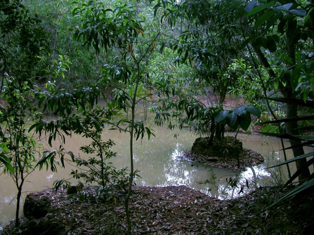
On the west side of the Auroville plateau, the land slopes from two directions to form a major gully at a canyon in a forest park called Darkali. The forest is a beautiful haven with a maze of aesthetic landscape features, dams, and a popular walking track full of peacocks and other wildlife. Darkali has undertaken remarkable water conservation efforts, yet it faces challenges due to proposed development plans.
How it all started
35 years ago, much of the land intended for this park belonged to the neighbouring village of Kottakarai. It was a barren wasteland when three Aurovilians first began digging, planting, and bunding by hand. After a year, they dug a borewell, installed a hand pump, and began living there, funded only by their own small personal means. Over time, enough water and topsoil was held on the land to nourish the growing trees through the dry season. When Auroville purchased the plots adjacent to the canyon, it suddenly became possible for the caretakers to envision water harvesting and ground water recharge on a much larger scale. They began constructing earth dams in the canyon at key points and planted around the canyon to stop erosion. They used stones to build solid spillways for six dams and created a huge water catchment area with a mini-excavator.
Harvesting water for Auroville and beyond
From the forested park down to the canyon, rainwater run-off from each landscape feature is guided into another area, and another, until all of the water is guided into the catchment area of the largest dam.
On an average year with 1.4 metres of rainfall, Darkali sees almost zero runoff from its 50 acres, and an estimated 4 million litres of water are harvested. At present, water from more than 60% of the area at the top of the Auroville plateau drains through Darkali during monsoons. The canyon’s overflow travels through neighbouring villages and connects finally to the Kaliveli wetlands 10 kilometres north of Auroville. Technical reports and water strategy recommendations stress that this is a sensitive area for water catchment and recharge strategies, both for Auroville and the sub-watershed (covering approximately 135 sq. km.).
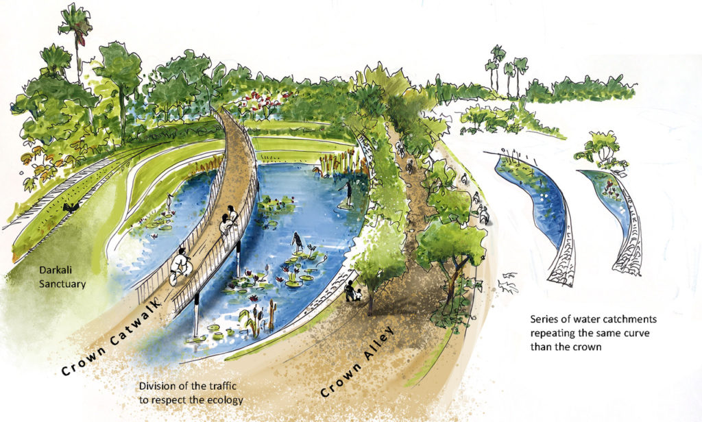
Crown Road and Right of Way
Before Auroville’s chief architect, Roger Anger, passed away, he had agreed to enlarge the boundaries of this particular green area. The new boundaries, including the canyon, were finalised on paper by the town planning group of the time, and officially signed in 2009.
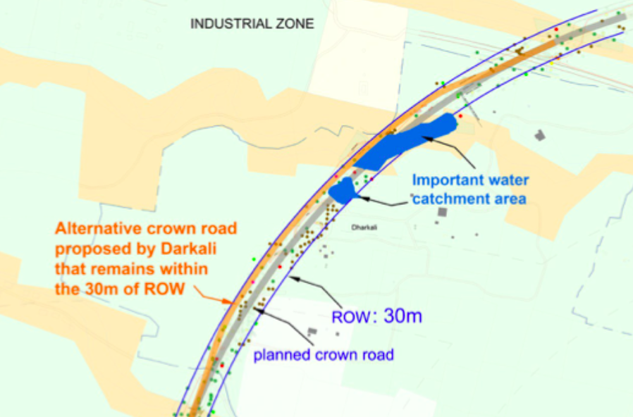
Over the years, Auroville has seen multiple markings and surveys for an internal circular corridor around the area designated as the Crown. The caretakers of Darkali forest park regularly sought out clear indications of where this corridor was meant to pass, and kept the dedicated strip of land free of major plantation in order to accommodate it. In 2012, a Technical Design Study of the Crown Road (commissioned by Auroville) plainly stated the need for an Environmental Impact Assessment of sensitive areas – defined as canyons, water recharge areas, and the entirety of Bliss and Darkali Forests – along the projected path. This has yet to be done, and is a legal requirement before large-scale development can take place.
Destruction
In 2021, the Town Development Council (‘ATDC’) wrongly appointed by the Office of the Secretary, Auroville Foundation (AVFO), revealed Crown Road plans with the Right of Way (ROW) newly mapped as a perfectly circular corridor. In Darkali, this means ploughing straight through and filling in important water harvesting structures, as well as clearing and eventually paving over much of the intended park area. Darkali’s caretakers repeatedly proposed a highly practicable solution – a six metre deviation that would keep the route within the overall 30 metre Right of Way, preserve water harvesting capacity, and save 75% of the trees.
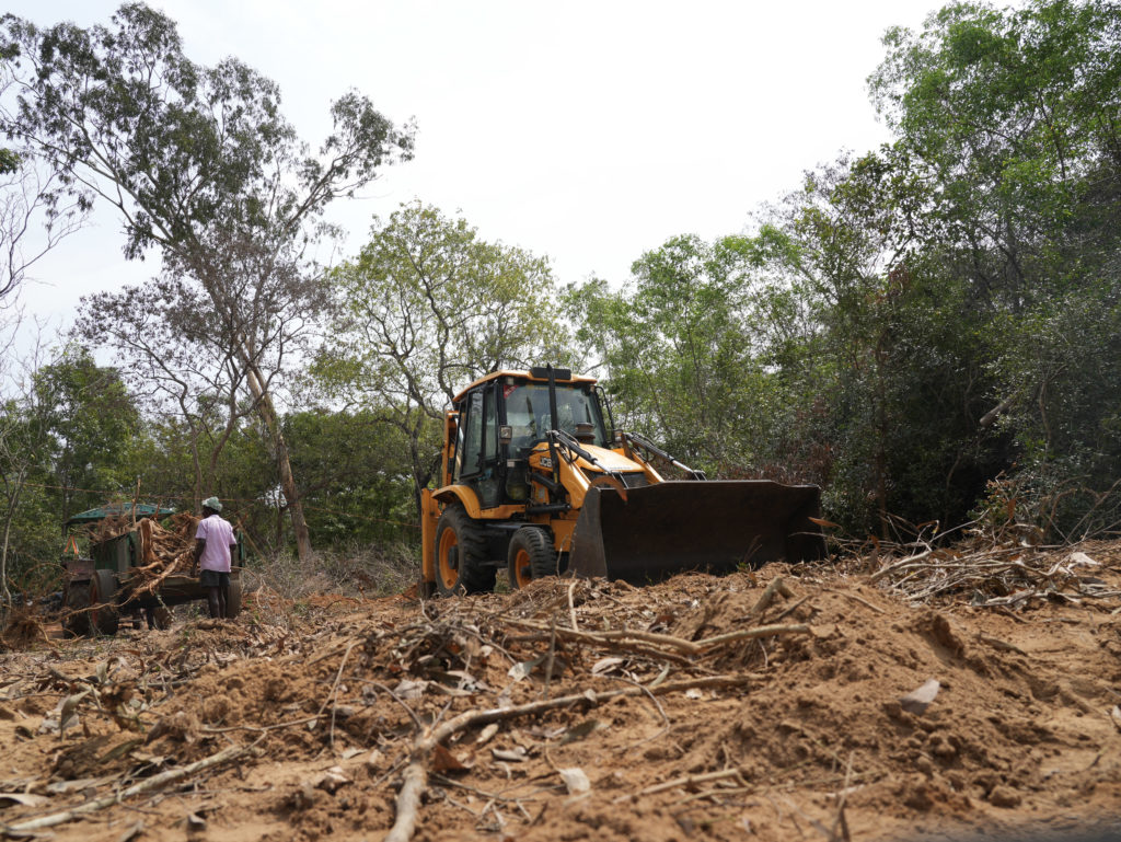
Nonetheless, bulldozers were sent to Darkali without notice in December 2021. A significant number of trees were cut down or uprooted before the National Green Tribunal issued a Stay Order that halted the destruction. Then, in March 2023, following publication of the NGT’s Joint Committee report, the AVFO ‘ATDC’ sent in untrained labourers who destroyed 197 trees, including protected species, beyond the corridor width permitted by the report. This ‘ATDC’ has made it clear that they intend to push ahead with a developmentally short-sighted approach.
The future is now
As much of India withers under a deadly summer heatwave, Darkali’s value as an ecological haven seems starkly evident. Auroville must learn how to flexibly incorporate such life-giving spaces into the urban fabric to ensure its own future.
Extracted from Voice of Auroville, Issue 02, July 2023